Cruising the Sea of Cortez
Section Two: Major anchorages between La Paz and Bahia de Los Angeles with the optional trip to San Felipe
In this section we will bring you a listing of some of the anchorages you should visit while in the Sea. Keep in mind that the distance from La Paz to San Felipe is 475 miles and it would be impossible to discuss every little nook and cranny along the way. This list serves as a basic suggestion of some of the anchorages to visit and what to watch for. The list also gives you ideas where to stop. You can see some on your way up and some on your way south.
Leaving La Paz Bay, your first stop could be Playa Pichilingue, just north of the Puerto Pichilingue commercial harbor. It has moderate Corumuel protection, good sandy holding ground, 2 good restaurants to decompress either when leaving or returning (nothing wrong with having a cold beer on a beach palapa restaurant) and transportation available to town in case you forgot something important. It can be a bit noisy at times due to the proximity of the commercial harbor traffic but not too bad.
Around the corner inside Roca Lobos is Caleta Lobos with good Corumuel protection, nice snorkeling, very quiet and only 6 miles from the La Paz entrance. Club Cruceros Note: As of December 2016 Caleta Lobos is closed to anchoring
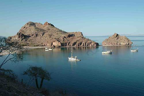
On the west side of Isla Espiritu Santos, Caleta Partida stands out with good Corumuel and moderate westerly protection. It is a very popular anchorage.
Continuing north, your next stop will be Isla San Francisco with The Hook on the southwest side being the most known anchorage. It is open to the south and west so be careful when Corumuels are predicted. A safer place in a Corumuel would be the East or North Side of the Island which offers excellent protection as well as great snorkeling.
Your next stop could be San Evaristo. The inner bay offers excellent all around protection with good holding. Water is available from the desalination plant on the beach (recent price was 5 pesos per 5 gallon jug). The general store offers minimal supplies. The north bight around the corner by the salt ponds offers good Corumuel and southerly protection. There is a new small palapa restaurant and bar in San Evaristo the south end of the bay.
From San Evaristo you have several options. You can go across to Isla San Jose and play a bit in Amortajada Bay or you can continue north. At the southern end of Amortajada Bay is a mangrove area where you can take a dinghy ride through. Sometimes this area is known to have no-see-ums, so beware.
After San Evaristo, your next stop going up the San Jose channel would be Puerto Los Gatos which offers great protection from the north and south. At this point you are out of the Corumuel affected areas. Be careful when entering. Stay offshore until you are abreast of the red rocks separating the north and south bight. Do not cut the corner. The south reef extends further than it looks. Once inside you will find good sandy holding ground, great hiking and diving.
Next up is one of the jewels of the Sea of Cortez – Agua Verde. When approaching from the south stay offshore till you are close to Punta San Marcial. You can pass through the channel separating Punta San Marcial and San Marcial Reef. Most cruising guides give good descriptions. Agua Verde is a big bay with many places to anchor. The most popular ones are the north and south bight by the fishing village. The village has two small general stores (tiendas) for local supply, fresh goat cheese in season and the main highway is 22 miles away by dirt road. There is a small restaurant in the village which may or may not be open. Check it out.
Where to go from Agua Verde? Several choices. Weather permitting you can go to Yellowstone Beach on the north side of Isla Monserrate about 13 miles to the north. Yellowstone has a long white sandy beach and offers good holding. Watch for a few scattered rocks.
Or you can go to Bahia Candeleros, about 17 miles to the north. The channel between the islands and Baja side offer good depth for crossing. Stay to the middle between Isla Pardo and the point. You can also cross between Isla Pardo and Isla Tijeras. Bahia Candeleros offers good holding. Once in a while you might get dying squid in the bay, mostly around June. When this happens, keep going since it gets pretty smelly. There is a big resort hotel ashore which offers car rentals, restaurants and bars.
Puerto Escondido is about another 6 miles to the north. That’s where Loreto Fest is held. You can get fuel and water at Singlar Marina’s fuel dock. To go to the town of Loreto or to hide when a hurricane threatens pick up a mooring from Singlar or anchor (the fee is the same). There is a small tienda, an excellent restaurant and a do -it-yourself laundry facility in the Singlar complex. Laundry can also be dropped off at the Tripui hotel down the road. The Yacht Club has an excellent book exchange. You can also anchor across the channel in Honeymoon Cove on Isla Danzante for free.
You can anchor in front of the town of Loreto in calm weather, even over night. Drop your hook in about 10 - 12 feet right off or north off the breakwater. Drive your dinghy inside the breakwater and tie up at the API dock.
Puerto Ballandra on Isla Carmen is your next stop. Good all around protection except westerlies. Excellent diving at the south point of the entrance. It can get buggy sometimes and bees also come for a visit once in a while. It is 9 miles across from Loreto. There are many additional coves on Isla Carmen being Marquer, V-Cove, La Lancha and Salinas.
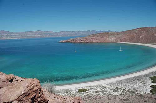
Caleta San Juanico is about 24 miles to the north of Puerto Ballandra and is another jewel of the Sea. With its many picturesque anchorages it’s a place you can spend a whole month without getting bored. Just watch for weather. If you have a southerly coming, go around the corner to La Ramada. Caleta San Juanico offers great diving, hiking, fishing and kayaking. Don’t forget to make your contribution to the “Cruisers Shrine” in the north bight.
From Caleta San Juanico it’s a 47 mile trip to Bahia Santo Domingo at the entrance to Bahia Concepcion. Be extremely cautious when rounding the point as you might get hit with sudden wind bursts of 25+ knots within seconds. We shredded a cruising kite when we got there. Just around the corner from Punta Concepcion and Punta Aguja is Bahia Santo Domingo and normally the first stop before entering Bahia Concepcion. It has good protection and holding and a great shelling beach.
From Bahia Santo Domingo you can have a variety of destinations in the bay. Some of the more popular ones are Playa Santispac, Playa El Burro (where 4th of July party takes place), Playa Coyote and Playa Santa Barbara. When entering the bay, favor the left side to the middle part of the channel since it shoals up rather quickly on the right side. Follow the cruising guides suggested routes between the islands. There are several reefs around. Eating establishments are the highly recommended Bertha’s (now run by Ceila under new ownership) in El Burro Cove, Buenaventura Sports Bar just before Isla Requeson for some killer Hamburgers and Ana’s in Santispac. Honorable mention should also be given to Scotty’s El Candil restaurant in Mulege. Good food and cocktails.
Leaving Bahia Concepcion head for Punta Chivato. Anchor in the corner on good sand holding ground under the Hotel. Good place to anchor when you have northerlies. There is a good shelling beach south of the anchorage a short dinghy ride away. Should wind pick up from south, go around the corner to Ensenada El Muerto.
You can travel between Isla Santa Ines islands and the Baja side. Keep an eye on your depth sounder, but 30 + feet of depth is the norm.
Isla San Marcos has several anchorages. The most popular ones are Sweet Pea Cove and the anchorage north of Punta Piedra Blanca. Sweet Pea has good sandy holding. The one north of it has a few rocky patches between the sand, so watch where you drop your hook. There are several caves just north of it and it is also a great snorkeling and diving area. It also serves as a staging point for entry into Santa Rosalia, should both marinas be full and you don’t want to anchor in the harbor. Keep in mind that the area between Isla San Marcos and Santa Rosalia is considered squid row. During the months of June and July there will be hundreds of pangas out at night hunting for the giant Humboldt squid.
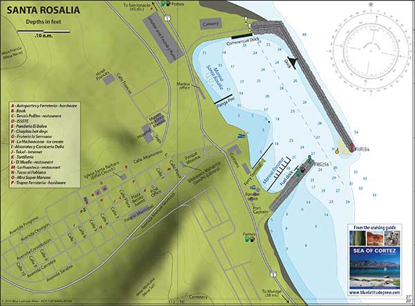
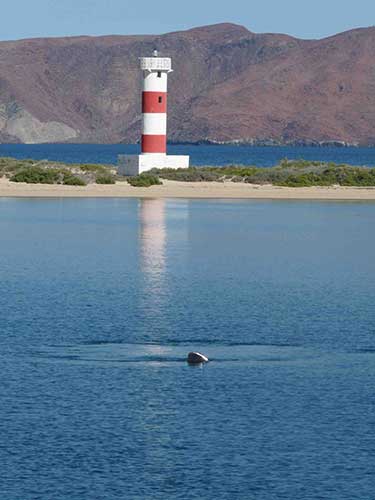
Santa Rosalia harbor has two marinas. Singlar Marina is on your left as you come through the breakwater. The older Marina Santa Rosalia is at the end of the harbor on your left. Singlar answers on VHF channel 16 and the old one monitors the VHF only once in a while if there is somebody in the office. You can anchor in the harbor close to the old marina. Leave enough room for the ferry and the Pemex fuel barges to enter and exit. Santa Rosalia is your last major point for provisioning before you head to Bahia de Los Angeles area. Also the last town with ATM’s and banks.
On your way north from Santa Rosalia you have a choice to go non-stop to San Francisquito (about 78 nautical miles) or stop in Punta Trinidad halfway (43 miles). Trinidad is open to the east and north and offers little protection to the south. It can get very rolly in there. We normally bite the bullet and go non-stop. Don’t forget to adjust your clocks and watches on this trip, since you are now on Pacific Time. Careful when you round Cabo Virgenes where you might experience sudden high westerly winds generating choppy seas combined with strong currents and rips around the point. It can get a bit uncomfortable. It is a good idea to stay off several miles when rounding this cape.
Bahia San Francisquito has the outer harbor and the inner harbor. The inner harbor is shallow (about 9-10 feet) but has good sandy holding ground between some grass patches. The outer harbor has two anchorages, one to the left of the inner harbor entrance and one to the right of it. The one to the left has a shelf close to shore with good holding. The one to the right further down has also good sand holding. Both are open to north winds.
Continuing north, you have many options. Midriff Islands and the Bahia de Las Animas area. The best one would be Isla Partida 30 miles to the north. Anchor inside the bay. Watch for westerlies and northerlies.
The next stops could be in either Ensenada el Alacran, Ensenada el Pescador or Ensenada el Quemado. All are a short ride away and good anchorages with sandy bottoms. Try them out now or later, you’ll have plenty of time.
Next anchorage is Puerto Don Juan. This is the local hurricane hole and you should make a point to at least take a “drive” through the anchorage to familiarize yourself with this place. Most likely you’ll return at least once during your stay in the Bahia de Los Angeles area due to a hurricane threat. At least you’ll know what it looks like.
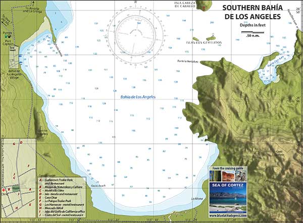
About 7 miles from Puerto Don Juan is Bahia de Los Angeles village. Anchor anywhere between the sand spit and the piers by the village. Just remember not to anchor too close to shore. Tide ranges are in the 10 feet + range. When landing your dinghy at Guillermo’s keep the tidal range in mind. If you land at high tide, you are fine. If you land at low tide, drag your dinghy all the way to the sea wall. Leaving the village give the point by the lighthouse a wide berth, especially during low tide during the full moon phase. You now have several anchorages to go to in the Bahia de Los Angeles area. La Mona is to the south and is where the full moon Jacuzzi parties are held every year. Listen for announcements of this event. It’s a fun day and you wouldn't want to miss it. To the north, you can go to the anchorage at Isla La Ventana, a one boat anchorage and open to westerlies, which can blow fiercely through that slot. This anchorage looks bigger than it actually is or the well protected bay of Ensenada la La Gringa. Bahia Las Rocas on Isla Coronado (Isla Smith) and the anchorage at Isla Mitlan few miles further up are also good places to spend some time to play, fish and snorkel. Watch for strong currents when swimming, noodeling or snorkeling in these two anchorages. They can be quite strong.
Puerto Refugio at the northern tip of Isla Angel de la Guarda is located about 40 miles north of Bahia de Los Angeles village and has several coves to anchor. This is the end of the normal cruising grounds in the Sea of Cortez.
There are a few more places to see north of Bahia de Los Angeles but they are not very attractive. If you need to go the USA, you could go all the way up to San Felipe, about 145 miles north of Bahia de Los Angeles and 120 miles south of the El Centro / USA border. Or you could go across to San Carlos with daily bus service to Phoenix.
The first stop on your way to San Filipe would be Bahia San Luis Gonzaga or Bahia Willard (Willard Bay) which could be considered another hurricane hole. Between Bahia San Luis Gonzaga and San Felipe is a small village called Puertecitos. This small gringo town is dead during the summer time. High season is during the winter months. As you head north, the tidal range gets bigger and you have to watch currents and tides as well as depth. The water is very warm (in the mid 90’s) and fishing is poor.
San Felipe has a Singlar marina and fuel dock. As you enter the breakwater stay in the middle until you hit the Singlar docks. When you reach the docks, turn to port and get a slip. Depth in the marina area is sufficient and we never had less than 8 feet under the keel during our stay there. Check the power outlets for voltage and correct polarity.
Click here to download and save Section 2 to your computer as a PDF
Section 2 contains the following files for download:
"Cruising the Sea of Cortez" has been compiled by Alex and Sue on M/V Maitairoa
To keep this series updated for future cruising generations please email mvmaitairoa@gmail.com
with your suggestions, corrections, additions and deletions.